The Lake at a Glance
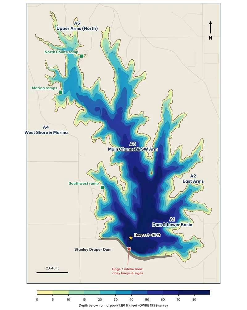
The whole lake, hillshaded from my 15-ft grid of OWRB's 1999 survey analysis. Area labels A1–A5 match the area chapters. Green squares are boat ramps from OpenStreetMap. The red X marks the USGS lake gage near the dam face, where the City's intake works sit; obey any buoys and signs there unverified.
The numbers
| Owner | City of Oklahoma City (water supply); fishing and boating permits through OKC Parks (OKC Fishing) |
| Built | Impounded 1962 on East Elm Creek (ODWC) |
| Size | 2,519 acres, 32 mi of shoreline, 87,296 acre-ft (ODWC); the OWRB 1999 shoreline polygon measures 2,561 acres analysis |
| Depth | Max 93.5 ft (ODWC; OWRB 1999). My grid: mean about 35 ft; 18% of the lake is under 10 ft and 28% is over 50 ft analysis |
| Water source | Pumped ~100 miles from Atoka Lake, which is fed in turn from McGee Creek Reservoir (OWRB) |
| Ramps / piers | Ramps at the Marina, Point 1, Point 21 and North Pointe (Rec Area 1); covered fishing piers at Points 4, 6, 9, 19 and 23 (OKC Fishing) |
| Lake gage | USACE / USGS station LSDO2 (USACE Tulsa) |
What makes Draper different
- It is a deep, steep canyon lake for central Oklahoma. The main channel runs to 60–93 ft, and most points drop from 10 ft to 30 ft within 150–250 ft of the bank analysis. That is unusual for the OKC metro and is the main reason this guide leans so hard on deep-water access.
- It is filled by pipeline, not by rain. The watershed is small. The City pumps water from Atoka. The lake "typically fills and drains slowly over several months, generally going up from fall through spring and dropping three to six feet over the summer" (OWRB 104(b)(3) report). There are no muddy spring floods to wreck a spawn, but also no rising water pushing fish into fresh flooded cover inference.
- Cover is scarce. ODWC's 1999 survey lists the habitat as "dam rip rap, submerged cut timber, and some aquatic vegetation," plus fish attractors the agency placed (fish condos, tire and pallet reefs) (ODWC 1999). On a lake this short on cover, any rock, brush or standing timber you find on your graph is worth more than the same thing on a typical lake inference.
- It went nearly dry for boats from 2010 to 2015. Pipeline pump work, then drought, dropped the lake well below pool. Boating was closed, and the lake did not refill until April 2015 (Wikipedia) unverified. Bass spawned in a smaller lake, and terrestrial brush grew on the exposed banks before the refill inference.
The areas
| Area | What it is | Spots |
|---|---|---|
| A1 · Dam & Lower Basin | Dam riprap, the 93-ft bowl, steep points either side | 7 |
| A2 · East Arms | Four long, narrow east-side creek arms | 11 |
| A3 · Main Channel & SW Arm | Old East Elm Creek channel, the offshore ridge, the southwest arm | 12 |
| A4 · West Shore & Marina | The busy west bank: Marina, piers, campgrounds | 7 |
| A5 · Upper Arms (North) | Shallow north end; spawning and fall water | 3 |
The Lake in 3-D
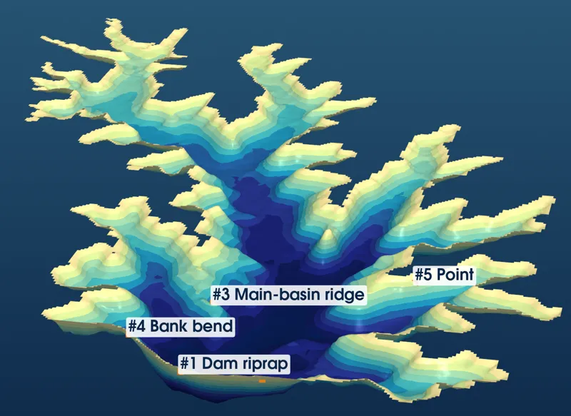
Looking north from above the dam. Built from my grid of the OWRB 1999 soundings, with depth exaggerated 10 times analysis. Labels mark the top five giant spots that are visible from this angle.
The 3-D view shows why the lower lake is the giant end. Five creek valleys come together in front of the dam into a single bowl 70–93 ft deep. Every point and bank around that bowl has deep water within a long cast analysis. North of the Marina, the arms flatten into broad, 10–25-ft basins: good spawning and fall water, but a long way from deep winter refuge analysisinference.