Area 4 · West Shore & Marina
The west bank from the Marina down past the Southwest ramp: the busiest water on the lake, with ramps, piers and campgrounds. analysis
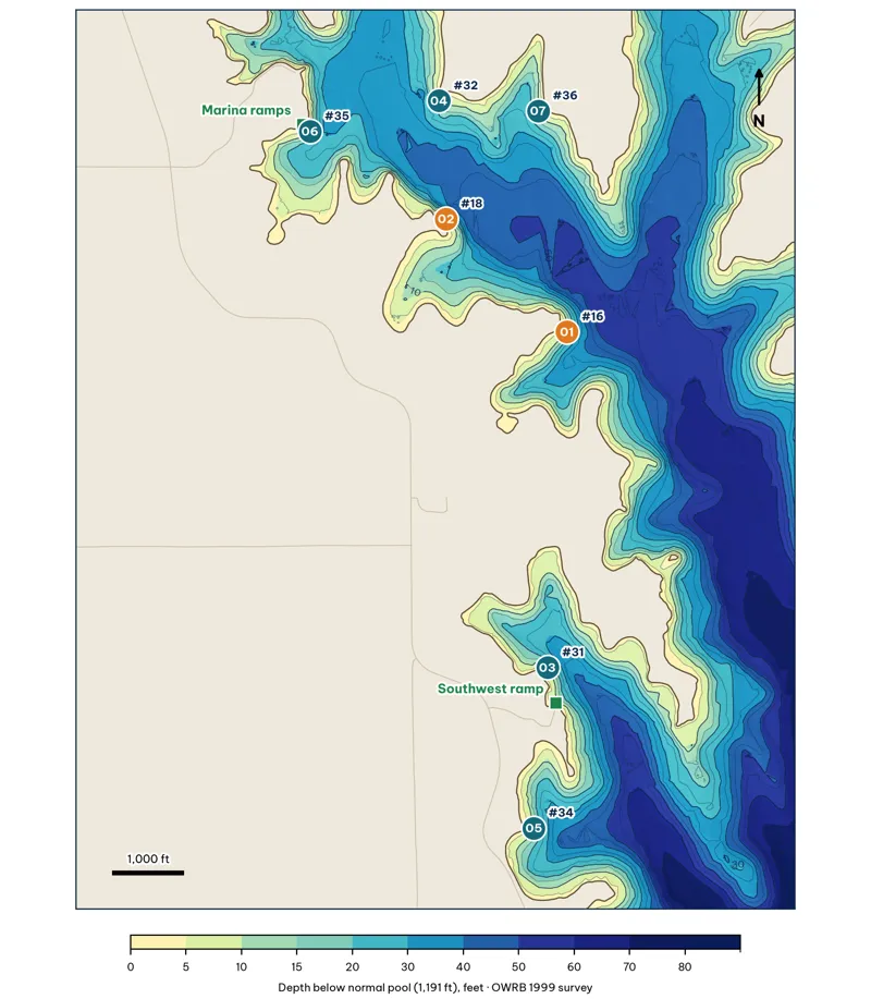
Area 4. Badge number = spot ID within the area; "#" = lake-wide giant rank. Red = score 80+, orange = 70–79, teal = under 70. Contours every 10 ft (labeled) from the OWRB 1999 survey grid.
Area 4 Spots: West Shore & Marina
7 spots: A4-01, A4-02, A4-03, A4-04, A4-05, A4-06, A4-07. Close-up maps from the OWRB 1999 survey; scores from the giant ranking.
A4-01 · Point (SE-facing)
#16 of 40Deep water4Cover3Forage4Low pressure4Data3Best: Winter · Pre-spawn · Summer
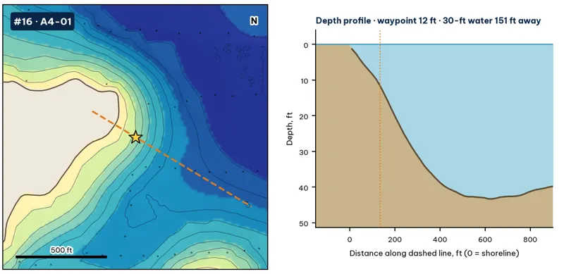
Star: target waypoint. Dashed orange line: the profile on the right. Black dots: OWRB 1999 sonar soundings. Contours every 5 ft from my grid of those soundings and OWRB's contours. Depths are below the 1,191-ft normal pool.
| Measure | Value |
|---|---|
| Depth at the waypoint | 12 ft analysis |
| Deep-water access | 20-ft water 67 ft away · 30-ft 151 ft · 40-ft 270 ft · deepest within 300 ft: 49 ft analysis |
| Slope | 12.5 ft per 100 ft (10 ft to 30 ft) analysis |
| Data support | 6 soundings within 300 ft analysis |
Why a giant would use it. A main-lake point with 30-ft water close to the bank. Points are the natural highways between the deep channel and the coves. Pre-spawn females stage on them, and wind-blown shad pile up on them in summer and fall. inference
How to fish it. Jerkbait and jig in pre-spawn; Texas-rigged worm and deep crankbait in summer; swimbait on windy days inference. Best wind: from the SE (blowing onto the spot) analysis. Oklahoma City's prevailing wind is south to southeast for most of the year, so south-facing banks get it most often (OCS).
A4-02 · Point (E-facing)
#18 of 40Deep water4Cover3Forage4Low pressure3Data4Best: Winter · Pre-spawn · Summer
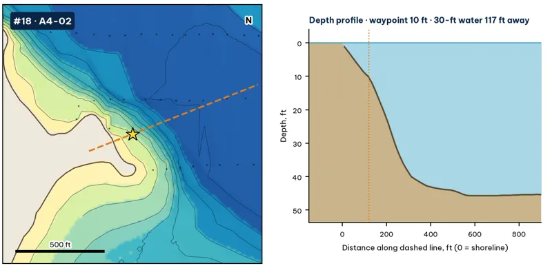
Star: target waypoint. Dashed orange line: the profile on the right. Black dots: OWRB 1999 sonar soundings. Contours every 5 ft from my grid of those soundings and OWRB's contours. Depths are below the 1,191-ft normal pool.
| Measure | Value |
|---|---|
| Depth at the waypoint | 10 ft analysis |
| Deep-water access | 20-ft water 64 ft away · 30-ft 117 ft · 40-ft 183 ft · deepest within 300 ft: 46 ft analysis |
| Slope | 16.1 ft per 100 ft (10 ft to 30 ft) analysis |
| Data support | 8 soundings within 300 ft analysis |
Why a giant would use it. A main-lake point with 30-ft water close to the bank. Points are the natural highways between the deep channel and the coves. Pre-spawn females stage on them, and wind-blown shad pile up on them in summer and fall. inference
How to fish it. Jerkbait and jig in pre-spawn; Texas-rigged worm and deep crankbait in summer; swimbait on windy days inference. Best wind: from the E (blowing onto the spot) analysis. Oklahoma City's prevailing wind is south to southeast for most of the year, so south-facing banks get it most often (OCS).
A4-03 · Point (NE-facing)
#31 of 40Deep water3Cover3Forage4Low pressure1Data4Best: Pre-spawn · Summer
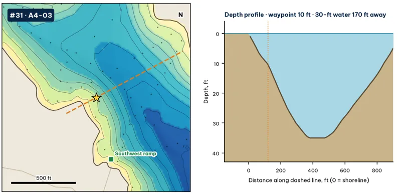
Star: target waypoint. Dashed orange line: the profile on the right. Black dots: OWRB 1999 sonar soundings. Contours every 5 ft from my grid of those soundings and OWRB's contours. Depths are below the 1,191-ft normal pool.
| Measure | Value |
|---|---|
| Depth at the waypoint | 10 ft analysis |
| Deep-water access | 20-ft water 75 ft away · 30-ft 170 ft · 40-ft 394 ft · deepest within 300 ft: 38 ft analysis |
| Slope | 11.2 ft per 100 ft (10 ft to 30 ft) analysis |
| Data support | 10 soundings within 300 ft analysis |
Why a giant would use it. A main-lake point with 30-ft water close to the bank. Points are the natural highways between the deep channel and the coves. Pre-spawn females stage on them, and wind-blown shad pile up on them in summer and fall. inference
How to fish it. Jerkbait and jig in pre-spawn; Texas-rigged worm and deep crankbait in summer; swimbait on windy days inference. Best wind: from the NE (blowing onto the spot) analysis. Oklahoma City's prevailing wind is south to southeast for most of the year, so south-facing banks get it most often (OCS).
A4-04 · Point (S-facing)
#32 of 40Deep water3Cover3Forage3Low pressure2Data5Best: Pre-spawn · Summer
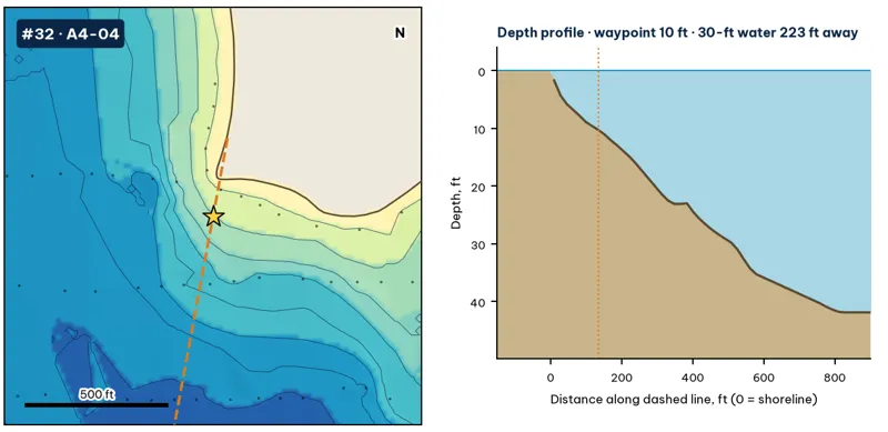
Star: target waypoint. Dashed orange line: the profile on the right. Black dots: OWRB 1999 sonar soundings. Contours every 5 ft from my grid of those soundings and OWRB's contours. Depths are below the 1,191-ft normal pool.
| Measure | Value |
|---|---|
| Depth at the waypoint | 10 ft analysis |
| Deep-water access | 20-ft water 121 ft away · 30-ft 223 ft · 40-ft 604 ft · deepest within 300 ft: 36 ft analysis |
| Slope | 5.1 ft per 100 ft (10 ft to 30 ft) analysis |
| Data support | 12 soundings within 300 ft analysis |
Why a giant would use it. A main-lake point with 30-ft water close to the bank. Points are the natural highways between the deep channel and the coves. Pre-spawn females stage on them, and wind-blown shad pile up on them in summer and fall. inference
How to fish it. Jerkbait and jig in pre-spawn; Texas-rigged worm and deep crankbait in summer; swimbait on windy days inference. Best wind: from the S (blowing onto the spot) analysis. Oklahoma City's prevailing wind is south to southeast for most of the year, so south-facing banks get it most often (OCS).
A4-05 · Bank bend (E-facing)
#34 of 40Deep water3Cover2Forage4Low pressure2Data3Best: Pre-spawn
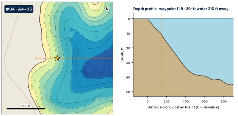
Star: target waypoint. Dashed orange line: the profile on the right. Black dots: OWRB 1999 sonar soundings. Contours every 5 ft from my grid of those soundings and OWRB's contours. Depths are below the 1,191-ft normal pool.
| Measure | Value |
|---|---|
| Depth at the waypoint | 11 ft analysis |
| Deep-water access | 20-ft water 105 ft away · 30-ft 210 ft · 40-ft 370 ft · deepest within 300 ft: 37 ft analysis |
| Slope | 9.4 ft per 100 ft (10 ft to 30 ft) analysis |
| Data support | 7 soundings within 300 ft analysis |
Why a giant would use it. A bend or secondary point where the bank swings toward the channel. The break tightens here, which concentrates fish moving along the bank. inference
How to fish it. Jig, shaky head or Texas rig worked down the break; squarebill over the top at dawn inference. Best wind: from the E (blowing onto the spot) analysis. Oklahoma City's prevailing wind is south to southeast for most of the year, so south-facing banks get it most often (OCS).
A4-06 · Point (SE-facing)
#35 of 40Deep water3Cover3Forage3Low pressure1Data5Best: Pre-spawn · Summer
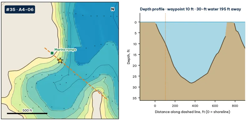
Star: target waypoint. Dashed orange line: the profile on the right. Black dots: OWRB 1999 sonar soundings. Contours every 5 ft from my grid of those soundings and OWRB's contours. Depths are below the 1,191-ft normal pool.
| Measure | Value |
|---|---|
| Depth at the waypoint | 10 ft analysis |
| Deep-water access | 20-ft water 81 ft away · 30-ft 195 ft · 40-ft 1215 ft · deepest within 300 ft: 32 ft analysis |
| Slope | ridge top to 60 ft within about 450 ft analysis |
| Data support | 11 soundings within 300 ft analysis |
Why a giant would use it. A main-lake point with 30-ft water close to the bank. Points are the natural highways between the deep channel and the coves. Pre-spawn females stage on them, and wind-blown shad pile up on them in summer and fall. inference
How to fish it. Jerkbait and jig in pre-spawn; Texas-rigged worm and deep crankbait in summer; swimbait on windy days inference. Best wind: from the SE (blowing onto the spot) analysis. Oklahoma City's prevailing wind is south to southeast for most of the year, so south-facing banks get it most often (OCS).
A4-07 · Bank bend (SW-facing)
#36 of 40Deep water2Cover2Forage3Low pressure3Data4Best: Pre-spawn
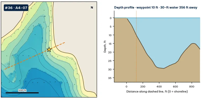
Star: target waypoint. Dashed orange line: the profile on the right. Black dots: OWRB 1999 sonar soundings. Contours every 5 ft from my grid of those soundings and OWRB's contours. Depths are below the 1,191-ft normal pool.
| Measure | Value |
|---|---|
| Depth at the waypoint | 10 ft analysis |
| Deep-water access | 20-ft water 114 ft away · 30-ft 356 ft · 40-ft 810 ft · deepest within 300 ft: 30 ft analysis |
| Slope | ridge top to 60 ft within about 450 ft analysis |
| Data support | 10 soundings within 300 ft analysis |
Why a giant would use it. A bend or secondary point where the bank swings toward the channel. The break tightens here, which concentrates fish moving along the bank. inference
How to fish it. Jig, shaky head or Texas rig worked down the break; squarebill over the top at dawn inference. Best wind: from the SW (blowing onto the spot) analysis. Oklahoma City's prevailing wind is south to southeast for most of the year, so south-facing banks get it most often (OCS).