Area 1 · Dam & Lower Basin
The deepest third of the lake: the dam face, the bowl in front of it (to about 93 ft), and the steep points on both sides. analysis
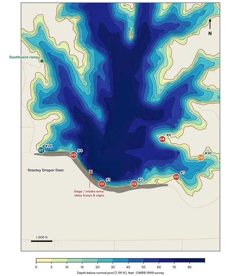
Area 1. Badge number = spot ID within the area; "#" = lake-wide giant rank. Red = score 80+, orange = 70–79, teal = under 70. Contours every 10 ft (labeled) from the OWRB 1999 survey grid.
Area 1 Spots: Dam & Lower Basin
7 spots: A1-01, A1-02, A1-03, A1-04, A1-05, A1-06, A1-07. Close-up maps from the OWRB 1999 survey; scores from the giant ranking.
A1-01 · Dam riprap (NE-facing)
#1 of 40Deep water4Cover4Forage4Low pressure5Data5Best: Winter · Pre-spawn · Summer · Fall
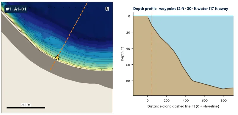
Star: target waypoint. Dashed orange line: the profile on the right. Black dots: OWRB 1999 sonar soundings. Contours every 5 ft from my grid of those soundings and OWRB's contours. Depths are below the 1,191-ft normal pool.
| Measure | Value |
|---|---|
| Depth at the waypoint | 12 ft analysis |
| Deep-water access | 20-ft water 47 ft away · 30-ft 117 ft · 40-ft 201 ft · deepest within 300 ft: 74 ft analysis |
| Slope | 16.1 ft per 100 ft (10 ft to 30 ft) analysis |
| Data support | 11 soundings within 300 ft analysis |
Why a giant would use it. Riprap on the dam face is the only big rock on this lake, which the 1999 ODWC survey lists, along with cut timber, as the main fish habitat. Rock holds crawfish and warms first in late winter. Here it drops into the deepest water in the lake, so a big fish can move up and down a few yards instead of a few hundred. inference
How to fish it. Crankbait (flat-sided in cold water) and football jig along the rock; in summer, a 10-in worm or deep crankbait at 15–25 ft inference. Best wind: from the NE (blowing onto the spot) analysis. Oklahoma City's prevailing wind is south to southeast for most of the year, so south-facing banks get it most often (OCS).
A1-02 · Dam riprap (N-facing)
#2 of 40Deep water4Cover4Forage4Low pressure5Data4Best: Winter · Pre-spawn · Summer · Fall
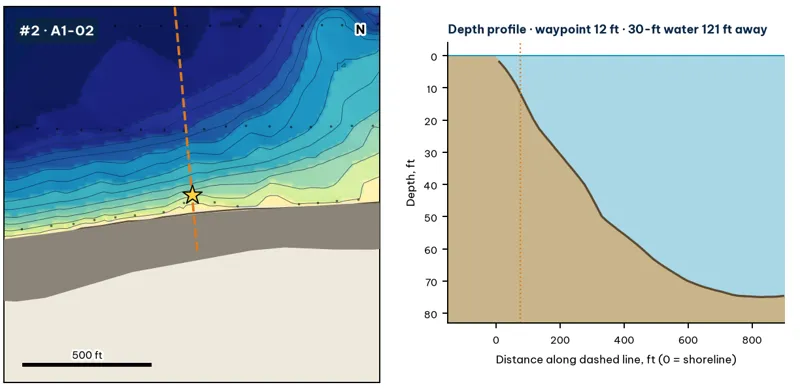
Star: target waypoint. Dashed orange line: the profile on the right. Black dots: OWRB 1999 sonar soundings. Contours every 5 ft from my grid of those soundings and OWRB's contours. Depths are below the 1,191-ft normal pool.
| Measure | Value |
|---|---|
| Depth at the waypoint | 12 ft analysis |
| Deep-water access | 20-ft water 45 ft away · 30-ft 121 ft · 40-ft 195 ft · deepest within 300 ft: 62 ft analysis |
| Slope | 16.1 ft per 100 ft (10 ft to 30 ft) analysis |
| Data support | 8 soundings within 300 ft analysis |
Why a giant would use it. Riprap on the dam face is the only big rock on this lake, which the 1999 ODWC survey lists, along with cut timber, as the main fish habitat. Rock holds crawfish and warms first in late winter. Here it drops into the deepest water in the lake, so a big fish can move up and down a few yards instead of a few hundred. inference
How to fish it. Crankbait (flat-sided in cold water) and football jig along the rock; in summer, a 10-in worm or deep crankbait at 15–25 ft inference. Best wind: from the N (blowing onto the spot) analysis. Oklahoma City's prevailing wind is south to southeast for most of the year, so south-facing banks get it most often (OCS).
A1-03 · Bank bend (NE-facing)
#4 of 40Deep water4Cover2Forage4Low pressure4Data5Best: Winter · Pre-spawn
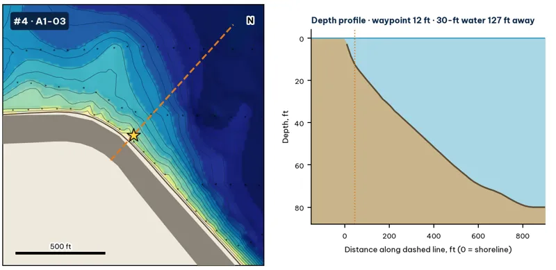
Star: target waypoint. Dashed orange line: the profile on the right. Black dots: OWRB 1999 sonar soundings. Contours every 5 ft from my grid of those soundings and OWRB's contours. Depths are below the 1,191-ft normal pool.
| Measure | Value |
|---|---|
| Depth at the waypoint | 12 ft analysis |
| Deep-water access | 20-ft water 47 ft away · 30-ft 127 ft · 40-ft 229 ft · deepest within 300 ft: 58 ft analysis |
| Slope | 14.0 ft per 100 ft (10 ft to 30 ft) analysis |
| Data support | 12 soundings within 300 ft analysis |
Why a giant would use it. A bend or secondary point where the bank swings toward the channel. The break tightens here, which concentrates fish moving along the bank. inference
How to fish it. Jig, shaky head or Texas rig worked down the break; squarebill over the top at dawn inference. Best wind: from the NE (blowing onto the spot) analysis. Oklahoma City's prevailing wind is south to southeast for most of the year, so south-facing banks get it most often (OCS).
A1-04 · Point (W-facing)
#6 of 40Deep water4Cover3Forage4Low pressure5Data5Best: Pre-spawn · Summer
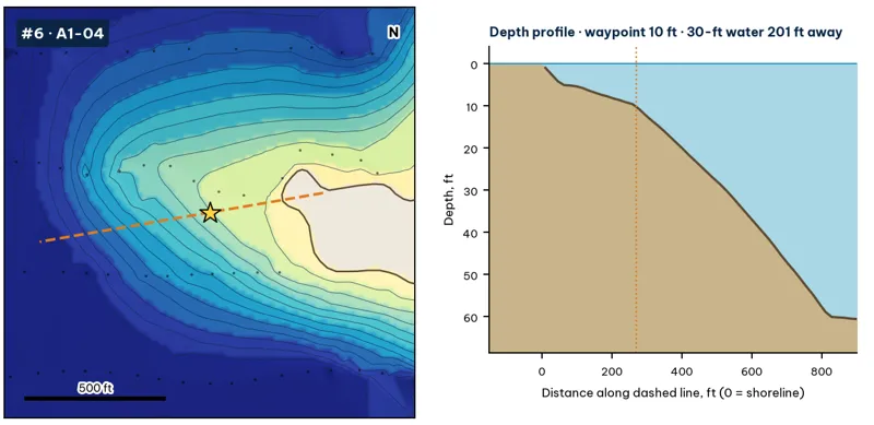
Star: target waypoint. Dashed orange line: the profile on the right. Black dots: OWRB 1999 sonar soundings. Contours every 5 ft from my grid of those soundings and OWRB's contours. Depths are below the 1,191-ft normal pool.
| Measure | Value |
|---|---|
| Depth at the waypoint | 10 ft analysis |
| Deep-water access | 20-ft water 106 ft away · 30-ft 201 ft · 40-ft 296 ft · deepest within 300 ft: 53 ft analysis |
| Slope | 8.0 ft per 100 ft (10 ft to 30 ft) analysis |
| Data support | 11 soundings within 300 ft analysis |
Why a giant would use it. A main-lake point with 30-ft water close to the bank. Points are the natural highways between the deep channel and the coves. Pre-spawn females stage on them, and wind-blown shad pile up on them in summer and fall. inference
How to fish it. Jerkbait and jig in pre-spawn; Texas-rigged worm and deep crankbait in summer; swimbait on windy days inference. Best wind: from the W (blowing onto the spot) analysis. Oklahoma City's prevailing wind is south to southeast for most of the year, so south-facing banks get it most often (OCS).
A1-05 · Point (NE-facing)
#7 of 40Deep water4Cover3Forage4Low pressure5Data5Best: Pre-spawn · Summer
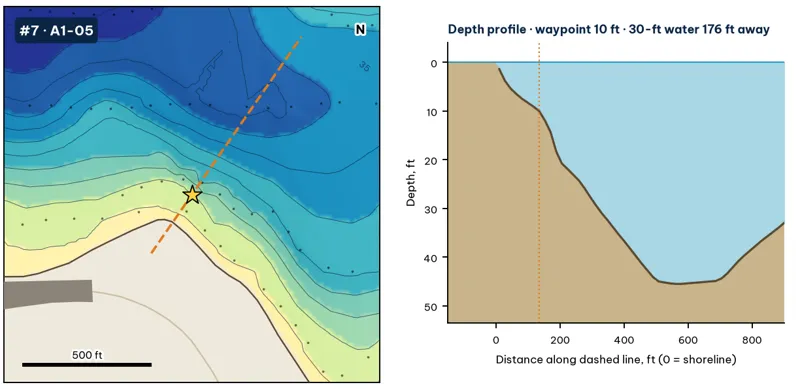
Star: target waypoint. Dashed orange line: the profile on the right. Black dots: OWRB 1999 sonar soundings. Contours every 5 ft from my grid of those soundings and OWRB's contours. Depths are below the 1,191-ft normal pool.
| Measure | Value |
|---|---|
| Depth at the waypoint | 10 ft analysis |
| Deep-water access | 20-ft water 54 ft away · 30-ft 176 ft · 40-ft 285 ft · deepest within 300 ft: 44 ft analysis |
| Slope | 10.2 ft per 100 ft (10 ft to 30 ft) analysis |
| Data support | 12 soundings within 300 ft analysis |
Why a giant would use it. A main-lake point with 30-ft water close to the bank. Points are the natural highways between the deep channel and the coves. Pre-spawn females stage on them, and wind-blown shad pile up on them in summer and fall. inference
How to fish it. Jerkbait and jig in pre-spawn; Texas-rigged worm and deep crankbait in summer; swimbait on windy days inference. Best wind: from the NE (blowing onto the spot) analysis. Oklahoma City's prevailing wind is south to southeast for most of the year, so south-facing banks get it most often (OCS).
A1-06 · Point (SE-facing)
#20 of 40Deep water3Cover3Forage3Low pressure5Data4Best: Pre-spawn · Summer
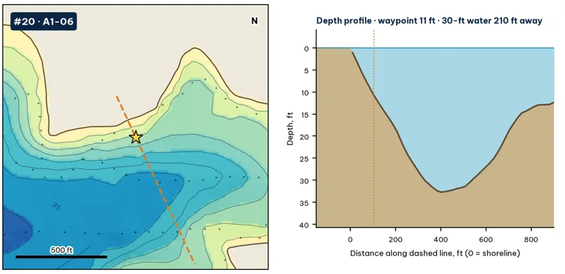
Star: target waypoint. Dashed orange line: the profile on the right. Black dots: OWRB 1999 sonar soundings. Contours every 5 ft from my grid of those soundings and OWRB's contours. Depths are below the 1,191-ft normal pool.
| Measure | Value |
|---|---|
| Depth at the waypoint | 11 ft analysis |
| Deep-water access | 20-ft water 114 ft away · 30-ft 210 ft · 40-ft 787 ft · deepest within 300 ft: 33 ft analysis |
| Slope | 8.6 ft per 100 ft (10 ft to 30 ft) analysis |
| Data support | 9 soundings within 300 ft analysis |
Why a giant would use it. A main-lake point with 30-ft water close to the bank. Points are the natural highways between the deep channel and the coves. Pre-spawn females stage on them, and wind-blown shad pile up on them in summer and fall. inference
How to fish it. Jerkbait and jig in pre-spawn; Texas-rigged worm and deep crankbait in summer; swimbait on windy days inference. Best wind: from the SE (blowing onto the spot) analysis. Oklahoma City's prevailing wind is south to southeast for most of the year, so south-facing banks get it most often (OCS).
A1-07 · Cove mouth (N-facing)
#26 of 40Deep water4Cover2Forage3Low pressure4Data5Best: Spawn · Fall
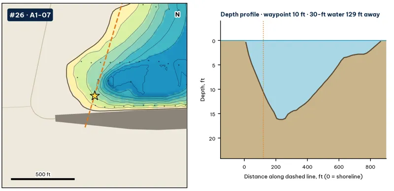
Star: target waypoint. Dashed orange line: the profile on the right. Black dots: OWRB 1999 sonar soundings. Contours every 5 ft from my grid of those soundings and OWRB's contours. Depths are below the 1,191-ft normal pool.
| Measure | Value |
|---|---|
| Depth at the waypoint | 10 ft analysis |
| Deep-water access | 20-ft water 75 ft away · 30-ft 129 ft · 40-ft 980 ft · deepest within 300 ft: 37 ft analysis |
| Slope | ridge top to 60 ft within about 450 ft analysis |
| Data support | 11 soundings within 300 ft analysis |
Why a giant would use it. A cove mouth with shallow flats behind it. It's a staging and spawning area in spring and a shad trap in fall. inference
How to fish it. Weightless stick worm, soft jerkbait and swim jig in spring; spinnerbait and topwater in fall inference. Best wind: from the N (blowing onto the spot) analysis. Oklahoma City's prevailing wind is south to southeast for most of the year, so south-facing banks get it most often (OCS).